Dubuque Division/Iowa & Dakota Division Fox Valley O Scalers/Elgin, IL
2. Staging yard (8 tracks) 90 feet long hanging from the ceiling 3. Cantilevered levels (one spot 7 feet deep) 4. Large frog turnout’s, #10 and #12’s. 5. Coal mine with 4- 50 foot long double ended tracks on a grade. 6. Large industries (railroad size) 7. Long staging tracks 90 feet each, double ended allowing multiple trains per track. 8. Large yards ( Marquette 400 cars) 9. Prototype influence in track planning and copying prototype towns. 10. Large urban city in beginning stages of modeling (Dubuque) 11. Swing bridge across an aisle 12. Long, multiple industry, house tracks per prototype. 13. Generous use of double ended tracks. 14. Lap siding at Spechts Ferry 15. Siding on a trestle at Edmore 16. Lap frog turnouts in Marquette engine terminal. 17. Wye with a diamond in Marquette.v 18. Interesting traffic mix of meat trains, a banana train, and the oil train. 19. Passing tracks up to 37 cars long. 20. Layout extends beyond house footprint. 21. Flowing curved fascias. 22. In addition, recessed turnout controls leaving a smooth fascia 23. Ramp from 9’ to 10’ deep basement 24. LED lighting for levels.
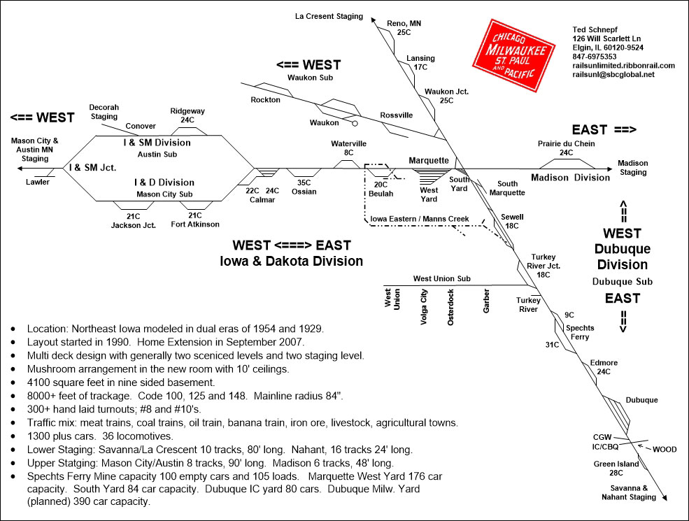 TOWN DIRECTORYIowa & Dakota Division (Marquette to Mason City/Austin)Beulah: Interchange with narrow gauge Iowa Eastern Railway - top of helper grade.Waterville: Small agricultural community with a creamery. East Ossian: Powerplant (Coal destination). Ossian: Large community with Rock Island interchange, a foundry, circular coal shed, cold storage, small packing plant and machinery company. Calmar Junction Yard: Creamery, elevator, door factory and pickle station. Ridgeway: Small farm community with main street facing the tracks. Conover: Junction with Decorah Line. Fort Atkinson: Farm town on a curve - crossing Turkey River. Jackson Junction: Junction with Iowa Division to Ceder Rapids and small farm town. Lawler: Small farm town.
BranchlineGarber: Schnepf warehouse, agricultural town.Osterdock: Brick plant. Volga City: Small agricultural town. West Union: Large agricultural town, creamery, RI interchange. Dubuque Division (Savanna/Nahant to LaCrescent)Green Island: Interchange Iowa DivisionDubuque: Large city with both IC and Milwaukee yards. CGW and CBQ are also present. Packing plant, trackage in the streets serving many large industries. Milwaukee Road has a 40 car freight house. Edmore: Limestone processing into cement (Vertical kilns), button factory. Spechts Ferry: Coal mine with 4-50’ loading tracks (One track is depressed for loading boxcars) & washer track. A ferry for carriages and autos. Turkey River Junction: Interchange with interurban/branchline. Turkey River: Small agricultural town. Sewell: Coal & coke processor and narrow gauge interchange (Wilderness Lumber Company.) South Marquette: River interchange - dock, warehouse, grain elevator. Marquette: Major terminal/yard. Wye at passenger station. South Yard is the arrival/departure yard. West Yard is the classification yard. 80’ turntable in engine terminal. Madison division connection (staged). Waukon Junction: Junction with branchline, coal & Oil Dealer. Lansing: Mississippi River town with a button factory and a live fish car pickup Reno, MN: Passing track, Coal & Oil Dealer. Waukon BranchRossville: Tiny farm town.Waukon: County Seat, farm town. Rockton: Iron mine and quarry. PRIMARY TRAFFICMeat (refers) - Eastbound loads - from Iowa and Minnesota.Coal - online mines, moving South, North and West. Stone products - from Edmore, Rockton, Marquette and Dubuque. Agricultural products - all towns. Oil, bananas, stock and autos - Other trains. Passenger trains: Through (“Marquette” & “Sioux”) and local trains. All Contents and Images © 1995 - 2016 Rails Unlimited | ||||
